
 Login
Login
Moosehead Lake, Maine Fishing Map – Lake Maps
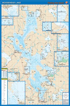 |
Moosehead Lake, Maine Fishing MapMoosehead Lake, located in west-central Piscataquis County, is Maine’s largest lake, covering over 117 square miles. The lake has a maximum water depth of 254 feet (when adjusted to full pond), located in the basin just east of Mount Kineo. Moosehead Lake is 1,029 feet above modern sea level. Moosehead Lake is currently managed for wild brook trout, wild lake trout, and wild and stocked landlocked salmon. There is also a fishery, primarily in the winter, for cusk (burbot). Brook trout are caught in the shallow areas of the lake in the spring and winter. $21.45
Shipping: 0.00
Category: Lake Maps Vendor: Fishing Hot Spots Vendor Item #: L902 Inventory: 1 Dated Added: 9/27/2014 8:25:21 PM  |
|
Quick Links Moosehead Lake News Moosehead Lake Photos Moosehead Lake Videos |


